
Katrina Proved Louisiana Needed Reliable Elevations—LSU’s GPS Network Still Provides Them Today
August 22, 2025
When Hurricane Katrina struck in 2005, Louisiana faced more than broken levees and flooded neighborhoods—it faced a broken map. For years, shifting ground and rising seas made the state’s official elevation benchmarks unreliable.
In the middle of the crisis, engineers and emergency responders needed to know exactly how high the floodwaters had climbed and where to focus rescue efforts.
The Louisiana Spatial Reference Center (LSRC) at LSU’s Center for GeoInformatics (C4G) provided the solution: a statewide network of reference GPS stations that offered precise, up-to-date measurements when no other system could.
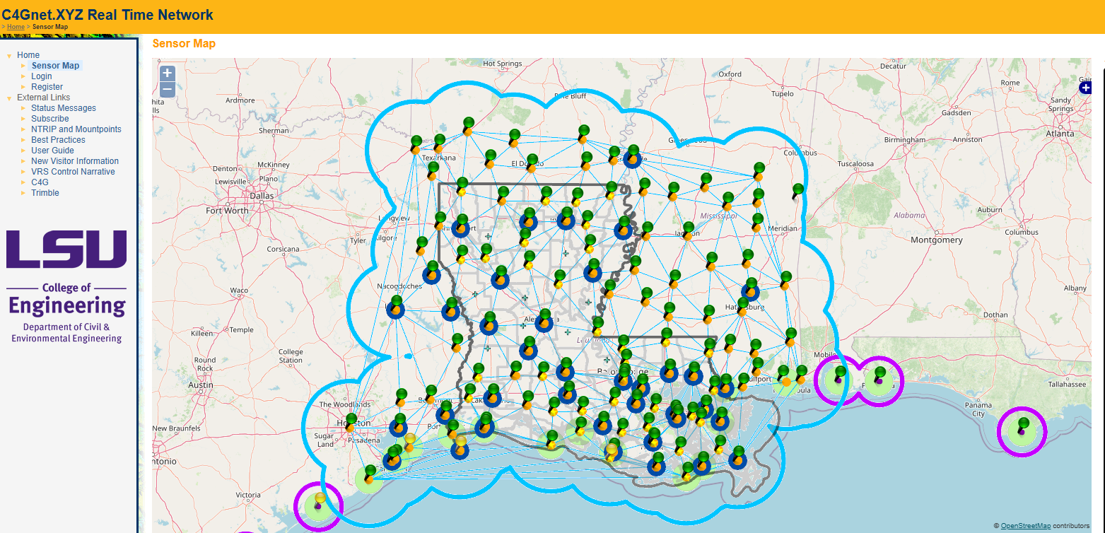
A network of continuously operating reference stations stretches across Louisiana.
“During Hurricanes Katrina and Rita, LSRC/C4G provided the ability to have accurate locations and heights—something that other agencies couldn’t do without officially certified benchmarks, which didn’t exist in Louisiana,” said J. Anthony Cavell, Louisiana state geodetic coordinator at C4G and accomplished surveyor.
The center’s work shaped the response to Katrina and Rita and has since become a cornerstone of Louisiana’s resilience, guiding everything from flood protection to infrastructure planning for the past 20 years.
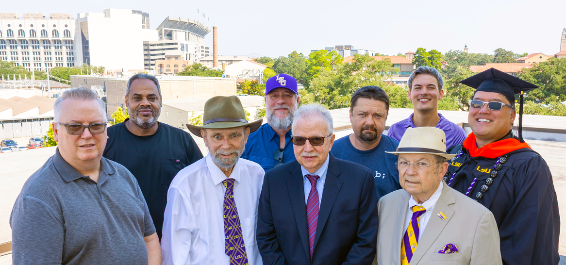
The C4G/LSRC staff, front row from left, Randy Osborne, Tony Cavell, George Voyiadjis, and Cliff Mugnier, and back row, Ahmed Abdalla, Larry Dunaway, Vasiliy Dubinin, Jon Cliburn, and Ben Fernández.
Fixing an Obsolete System
The LSRC’s story began years before Katrina.
By the late 20th century, scientists knew Louisiana was sinking, and official elevation benchmarks could no longer be trusted. In 2001, the National Geodetic Survey, or NGS, went so far as to declare the state’s entire system of certified elevations obsolete.
LSU geologist Roy Dokka, founder of C4G
Enter LSU geologist Roy Dokka, founder of C4G, to take on the challenge of studying the behavior of Louisiana's geology from faulting and subsidence to salt domes. He brought together experts and surveyors from across the state and helped rebuild Louisiana’s geodetic foundation with modern GPS technology so the state could measure its land and water with accuracy again.
The team partnered with the NGS to install a network of continuously operating reference stations (CORS) across Louisiana. Each station is a permanent GPS receiver that provides a constant, precise reference point for measuring position and elevation.
“Roy Dokka’s placing of permanent GPS stations to study the geology was the perfect tool to provide survey control,” Cavell said. “NGS recognized this and partnered with C4G to form the Louisiana Spatial Reference Center in 2002.”
By linking these stations, LSRC gave surveyors, engineers, and agencies the ability to pinpoint locations within centimeters—whether they were mapping levees, planning roads, or monitoring coastal change.
“This method could be accessed via cell phone over the Internet, meaning surveyors could get the results of a position to fractions of an inch in the field while working,” Cavell said.
In addition to Dokka, Cavell cited the contributions of several others, including:
- Clifford Mugnier, an LSU Department of Civil and Environmental Engineering instructor and accomplished programmer and geodesist
- Kurt Shinkle, a student of Dokka’s who studied decades of surveys to understand and help address the vertical displacement of benchmarks
- Randy Osborne, network manager for C4G, who continues to advance the technology underpinning LSRC’s work.
Katrina and Rita
When Katrina and then Rita struck in 2005, Louisiana had no certified elevation benchmarks to rely on. The LSRC’s GPS reference network became the only accurate foundation available, and federal, state, and local agencies turned to it immediately. With this data, they were able to:
- Map the extent of flooding to see exactly which areas were under water.
- Locate stranded residents and abandoned pets with precision coordinates.
- Measure the true heights of levees, revealing weaknesses that had gone unnoticed.
- Correct storm surge models, making predictions far more accurate for the future.
In the chaos of those weeks, LSRC provided the steady reference point needed to guide rescue, response, and recovery.
For example, the Society for the Prevention of Cruelty to Animals called on LSRC to learn how they might be able to locate pets that had been left behind in New Orleans, using little more than reported locations of pets recorded by rescuers. Cavell teamed up with Dina Knight to help.
“Dina Knight and I worked to assign GPS locations—latitude and longitude—to the verbal descriptions the SPCA had received,” he said. “Working through the night, Dina was able to assign the locations, and I formatted them appropriately for GPS use, and we provided the lists and some receivers to the SPCA.
“They reported good success with the effort and indeed, gave C4G a citation for the work we did.”
Decades of Innovation
Nearly two decades after Katrina and Rita, the Louisiana Spatial Reference Center has grown into one of the strongest real-time GPS networks in the country.
From its base at LSU, it continues to anchor Louisiana within the National Spatial Reference System, ensuring the state’s data is consistent with national and global standards.
Today, LSRC provides reliable geodetic data that ensures:
- Safer construction of roads, bridges, and levees.
- Accurate flood maps that guide insurance, evacuation, and rebuilding.
- Faster disaster response, with agencies working from the same precise information.
- Better long-term models of land loss and sea level rise, critical for coastal planning.
Cavell said anyone who cares about evacuation routes that don’t flood, levees that work as designed, and accurate flood elevations should care about LSRC’s work.
“Practically, no civil engineering project is accomplished without a prescribed location, size, orientation, or elevation. The foundation for that is geodetic control. Historically, this has been passive control or benchmarks. Today, it is active control using the state’s network of continuously operating reference stations.”
C4G Team Members
- Dr. George Z. Voyiadjis, C4G Director
- J. Anthony Cavell PLS CFedS, Louisiana State Geodetic Coordinator
- Randy Osborne, Network Manager
- Larry Dunaway, Assistant Director of Field Operations
- Vasiliy P Dubinin, Network Analyst
- Clifford J. Mugnier, Chief of Geodesy, (Emeritus)
- Benjamin A. Fernandez, PE, LSI Geodetic Surveyor
- Jon Cliburn, Research Associate
- Ahmed Abdalla, Research Assistant Professor
- Yaneng Zhou, Research Assistant Professor
The C4G was moved into the Department of Civil and Environmental Engineering from Sponsored Programs following the death of Dr. Dokka in August 2011. Dr. George Voyiadjis is Chairman Department and serves as Director of C4G today.
Turning Tragedy into Impact
Explore LSU’s role in response, recovery, resilience, and research following Hurricane Katrina.